Tag: Quartierplanung

  • Thun North is developing into a new district

    Thun North is developing into a new district

    The future new district of Thun North is one of the four most important cantonal development priorities and the most important in the Bernese Oberland, according to a statement from the city of Thun. A future-oriented urban quarter and a business location with supra-regional appeal is to be created here on a 60-hectare site. The area will be accessed via a new S-Bahn station.

    Half of the site belongs to Armasuisse Real Estateand half to RUAG Real Estate AG. In 2025, the city of Thun conducted a so-called workshop process with them and BLS for the core area around the planned railway station. Three interdisciplinary teams worked with experts and various stakeholders to develop proposals. From these, an advisory committee derived key parameters for further development.

    The basic framework of the new district is to be formed by open spaces. This will be characterised by the Aare river, the roads, the railway area and the townscape. The existing shed roof hall will form the backbone of the complex. The two landowners want to concentrate their closed industrial sites on the area west of the Alpine Bridge and on the grounds of the textile centre. Mixed uses are planned outside these areas. The Swiss Federal Laboratories for Materials Testing and Research (Empa) will also be one of the key players with its new campus.

    The results of the workshop process will be on display at Thun Town Hall until 6 March.

  • Relocation creates development opportunity with lake view

    Relocation creates development opportunity with lake view

    Because it no longer meets the current requirements for a modern health centre, Lucerne Cantonal Hospital will be relocated to Schenkon together with the Seeblick nursing home. According to a statement, the canton, as the owner, and the city of Sursee want to plan an attractive future for the 47,000 square metre site.

    Initial assessments indicate that the site is suitable for mixed-use development with residential and commercial premises. This would allow for the creation of residential facilities for families, couples, singles and senior citizens, with services and restaurants completing the site. The site, located above Lake Sempach, is in close proximity to the old town of Sursee and already has good access to various modes of transport.

    “The move opens up a unique opportunity to repurpose the previous location in Sursee,” said Reto Wyss, member of the cantonal government, in the announcement. “This attractive site with lake views in a good location is to be rezoned for this purpose. The next planning steps will show what is feasible and where.” The planning phase for the new neighbourhood is set to begin in spring 2026, when the hospital starts to move. Various meetings with the local population and interest groups are planned. The site is expected to be vacant from 2034 and could be redeveloped. The possibility of incorporating the existing building fabric is also being considered.

  • Future area in the north of Basel creates living and working space

    Future area in the north of Basel creates living and working space

    The Klybeck site in the border triangle of Basel is to become a modern neighbourhood on the banks of the Rhine. According to a press release, the planning partners Canton Basel-Stadt, Swiss Life and Rhystadt have initiated the klybeckplus indicative project, which forms the basis for the utilisation planning.

    The approximately 30-hectare site is to become a mixed neighbourhood with residential complexes, commercial buildings and parks. The aim is to create living space for 8,500 people. According to the plans, a third of the flats will be made available to the public for rent at cost. In addition, 7500 jobs are to be created. The two owners, Swiss Life and Rhystadt, will invest 3 billion Swiss francs in the renovations, according to the press release.

    “The finalised indicative project, as it is now available, offers a good basis for realising the enormous potential of the site and creating significant and, above all, long-term added value for the population and the entire region,” Christian Mutschler from Rhystadt is quoted as saying in the press release. Jürgen Friedrichs from Swiss Life adds: “The indicative project shows how the diverse objectives from residential to open space can be combined while at the same time ensuring structural, spatial planning and economic feasibility.” District President Conradin Cramer is convinced that the project will create an “attractive new part of the city for the well-being of the population”.

  • From the depot to a climate-resilient urban district

    From the depot to a climate-resilient urban district

    The starting point for the development is the withdrawal of the CKW depot in the context of the large-scale transformation around Seetalplatz. Based on a two-stage study commissioned by CKW and the city of Lucerne, the “Habitat – Quartier im Hain” project was selected in 2022. The careful handling of existing buildings was decisive. In particular, the Shedhalle and the consistent integration of open spaces and rainwater management.

    The ideas of the winning project were then applied to the entire perimeter of the development plan and enshrined in planning law. The result is a coordinated overall figure that combines private properties and the former factory yard area into an urban development whole.

    Urban development, mixed use and sponge city
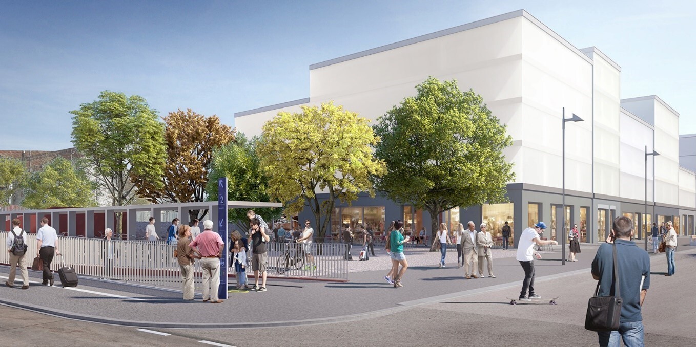
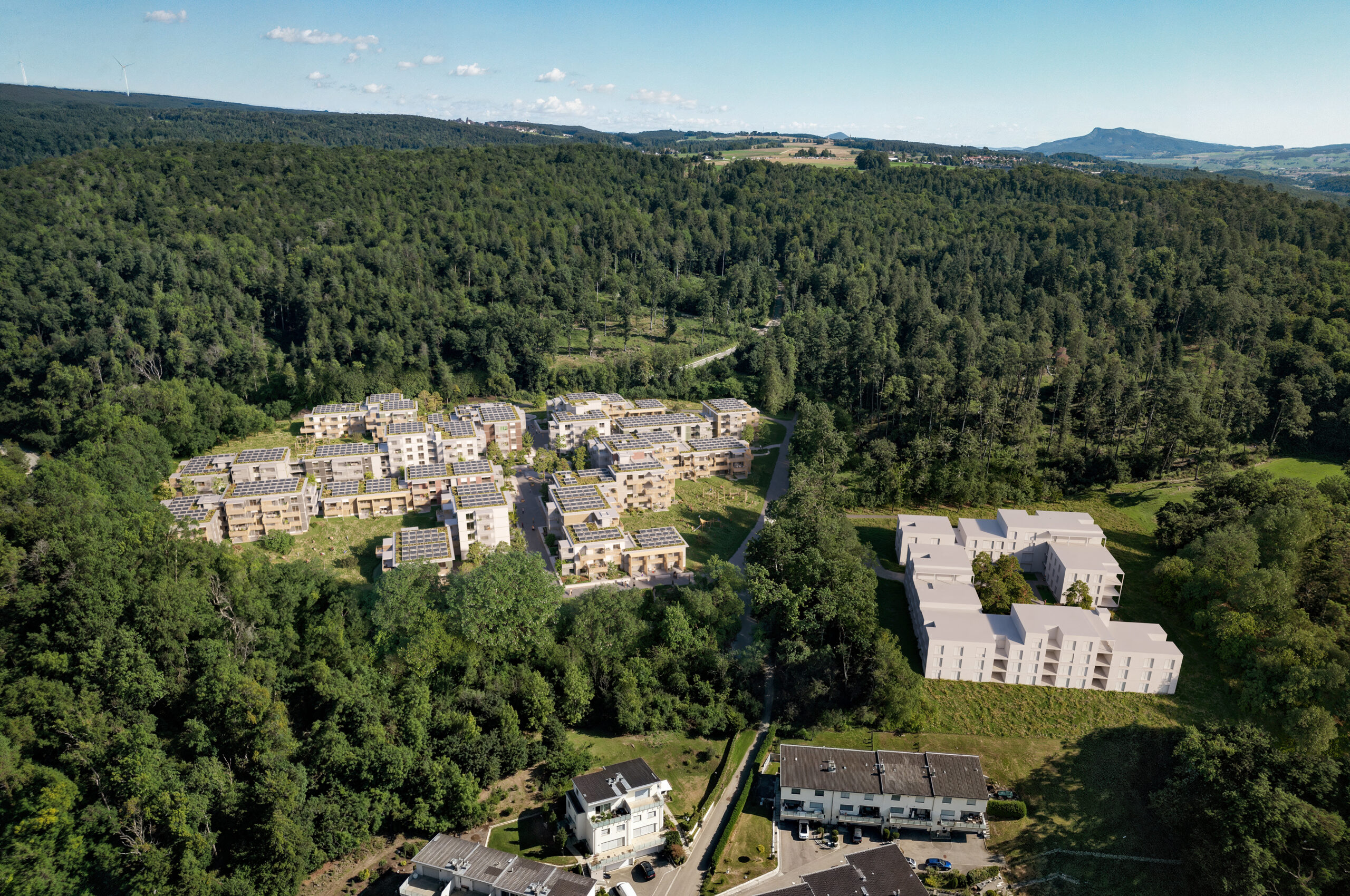
    For reasons of noise and urban space, the north-eastern part of the area is characterized by larger, mixed-use buildings in closed construction. Living, working, services and first floor uses are concentrated here along streets and squares. The western part focuses on open residential buildings, connected green spaces and paths that link the adjacent neighborhoods.

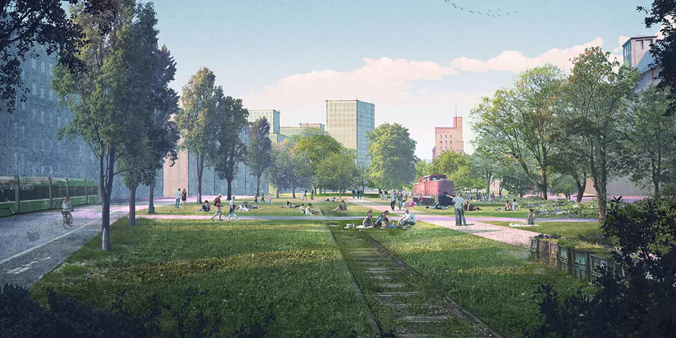
    The central element is a topographical depression in the west, a former floodplain. It serves as a retention area for rainwater and forms the basis of the “urban grove”, which characterizes the district with trees, infiltration areas and a cooling microclimate. Rainwater management, climate-adapted open space design and the sponge city principle thus become key components of the district’s identity.

    Social mix and diversity
    When completed, around 700 to 800 additional apartments are planned for Reussbühl West, at least 20 percent of which will be non-profit. They will be supplemented by multi-purpose rooms and around 15,000 to 18,000 square meters of work space for businesses and services. Short-term rentals will be limited to the areas already available today and are only permitted in construction site C9. This is a deliberate signal in favor of long-term residential and neighborhood structures.

    The existing shed hall will be opened up for public-oriented uses and will function as an address for culture, leisure or small-scale businesses. Together with the first floor uses of the new buildings, a mixed-use, all-day lively environment will be created that closely interlinks living, working and public facilities.

    Legal planning basis and timeline
    The “Reussbühl West” development plan sets out the main elements of the urban design and the distribution of uses in a way that is binding on the landowner and allows for staggered implementation. It is open to the public from November 24 to December 23, 2025. Objections and negotiations will be incorporated into further processing before the plan is submitted to the City Council.

    Together with the “Reussbühl Ost” development plan, which is already legally binding, this will create a legal planning framework for an upgraded, mixed-use district with a total of around 1,000 additional apartments and 15 to 20 percent commercial space. The densification will take place gradually. The first non-profit apartments and new commercial space are already under construction in Reussbühl Ost, marking the transition from an industrial area to the urban city building block of the next generation.

  • A visionary urban development project

    A visionary urban development project

    The new urban quarter covers an area of 125,600 square meters and will provide space for around 1,700 residents and the same number of jobs. The development is based on a sustainable urban model that combines both dense construction and natural recreational zones. The project relieves pressure on the city center and at the same time creates modern, well-developed commercial areas that strengthen Solothurn’s attractiveness as a business location.

    Living space for all generations
    The new district is based on well thought-out usage concepts that are tailored to the needs of a growing urban society. A variety of housing options for singles, families and senior citizens, modern workspaces with flexible usage options as well as high-quality green and recreational spaces that contribute to the quality of life are being created. The urban location between the Aare and the old town combines the advantages of city life with the amenities of sport and recreation in the most beautiful natural surroundings. Generous public spaces and traffic-calmed zones promote a high quality of stay and support social interaction.

    Urban development with a strong neighborhood spirit
    Solothurn Weitblick is more than just a construction project, it is a model for future-oriented urban development. The mix of different forms of housing, cooperative and private residential property and a consistent focus on pedestrians promote a strong neighborhood identity. Meeting zones, green promenades and well thought-out spatial structures invite people to linger and create a lively district that encourages active participation.

    Pioneer for sustainable urban planning
    The project focuses on innovative concepts for climate adaptation. The “sponge city” principle is used to store and evaporate rainwater in order to reduce heat islands and increase resistance to heavy rainfall events. Green roofs, water systems and retention basins contribute to a pleasant microclimate and sustainably improve the district’s environmental balance.

    First construction stages successfully completed
    Development of the area has already begun. In April 2023, work began on the Brühlhof Promenade, which has been open to pedestrians and cyclists since fall 2023. Work on Oberhofstrasse and key transport links has been underway since spring 2024. The first infrastructure measures should be completed by the end of the year, creating the basis for further neighborhood development.

    A model district for the future
    The new urban quarter will create a vibrant center for modern living and working. The successful combination of city and nature and a clear vision will create a unique space for future generations. This forward-looking project sets standards for the urban development of the future and offers Solothurn the opportunity to further strengthen its identity as a liveable and innovative city.

  • Start of construction of the forest town Im Pantli

    Start of construction of the forest town Im Pantli

    Halter AG has begun construction of the Waldstadt in Pantli. The ground-breaking ceremony for the residential project in the Pantli forest clearing in Schaffhausen took place on 10 January, the Schlieren-based property developer announced in a press release. The 214 condominiums planned in Waldstadt are being realised by Halter in collaboration with DOST Architektur GmbH from Schaffhausen.

    “The Waldstadt project in Pantli is making a valuable contribution to urban development,” says Mayor Peter Neukomm in the press release, quoting from his speech at the ground-breaking ceremony. “The development should serve as a model for future construction projects and strengthen Schaffhausen as a location for sustainable and innovative living.” Waldstadt is designed as living space for different living models.

    Specifically, the residential project aims to appeal to families and couples as well as singles and commuters. A kindergarten and daycare centre are also planned. Open spaces and communal facilities are intended to create “ideal conditions for harmonious coexistence”, according to the press release.

    Planning and realisation are based on the requirements of the Swiss sustainability standard. Around two and a half years have been estimated as the construction period for the first stage. The first of the 2.5- to 5.5-room flats should be ready for occupancy as early as next year.

  • More clarity for building lines in the canton of Zurich

    More clarity for building lines in the canton of Zurich

    In the canton of Zurich, traffic construction lines secure the space for infrastructure. Buildings that protrude into this area are only permitted under certain conditions. However, due to legal amendments in the past, uncertainties have arisen, particularly in the case of projecting building parts such as balconies and bay windows.

    With the planned revision of the Planning and Building Act, the cantonal government wants to eliminate these uncertainties. “We only want to restrict balconies and bay windows to the extent necessary for land protection and urban design,” explains Carmen Walker Späh, Director of Economic Affairs.

    In addition, the construction of easily removable small buildings such as bicycle shelters, solar panels or container boxes is to be made easier. While such buildings can already be authorised in the building line area today, this should also be possible in the road clearance area in future.

    Simplified adjustment of building lines
    Another key element of the revised law concerns the adjustment of building lines that were established as part of a neighbourhood plan procedure. In future, these changes should be possible in the ordinary procedure, thereby avoiding time-consuming neighbourhood plan revisions.

    Positive consultation and next step
    The proposed changes met with broad approval in the consultation. The majority of the 70 or so participants supported the amendments, although some of the submissions led to the draft being made more precise.

    The revised bill has now been submitted to the Cantonal Council for further consultation and to the relevant committee for examination. The aim is to create greater planning and legal certainty through clear legal regulations.

  • Preparations begin for harbour railway relocation in Basel

    Preparations begin for harbour railway relocation in Basel

    The city of Basel is planning a large-scale transformation of the Klybeck and Westquai areas. Living and working space for around 8,000 people is to be created there, complemented by green and open spaces. In order to better connect the neighbourhoods to the Rhine and the meadow, the existing harbour railway will have to be removed.

    The Grand Council approved a loan of CHF 36 million for this in June 2024. These funds will be used to relocate the harbour railway and other infrastructure facilities, including the customs metering station of Gasverbund Mittelland AG (GVM).

    Replacement construction of the customs metering station as the first step
    The first step will be to relocate the customs metering station, which feeds the regional gas network, to a new site in the Lange Erlen near Freiburgerstrasse. Construction work will begin in March 2025 and should be completed by the end of 2026. As the construction of a high-pressure gas pipeline in a residential area is not permitted, this location was chosen as the only solution that could be authorised.

    Special protective measures apply to the existing trees and the water protection zones. Any necessary tree felling will be compensated for by reforestation and replacement areas.

    Construction site coordination to minimise disruption
    Other major projects are being carried out in the surrounding area in parallel with the construction of the new customs measuring station. Deutsche Bahn is building a new Wiesenbrücke bridge, while the Basel-Stadt civil engineering office is working with IWB to renovate Freiburgerstrasse. All the work is being closely coordinated in order to clearly signal diversions for traffic and minimise disruption.

    With these measures, Basel-Stadt is taking an important step towards sustainable urban development and creating the basis for new, liveable neighbourhoods on the waterfront.

  • Preventing heat islands in the planning stage

    Preventing heat islands in the planning stage

    Climate change is causing problems for cities, especially in summer. “Heat island” has become a ubiquitous topic. However, those who plan larger neighbourhoods can avoid heat accumulation. The decisive factors here are the setting of the buildings in line with their surroundings, the choice of materials for façades and outdoor areas, green spaces and clever shading. The effects of these factors should actually be taken into account at an early planning stage. For this, however, architects would have to consult computer models that can calculate the impact of the decisive factors for a specific location. The problem with the existing models is that the calculation is time-consuming and costly. For this reason, they are usually not used at an early stage. The Lucerne University of Applied Sciences and Arts (HSLU) has now developed a new interactive neighbourhood climate modelling (QKM), which is limited to phase-specific information and delivers results in seconds. The project was financed by the Infinite Elements Foundation and the HSLU.

    Things have to move fast in the planning phase
    For large-scale construction projects, architectural firms usually apply in an elaborate competition procedure under high time pressure. “They have to consider a multitude of requirements in their design, one of which is the microclimate,” explains simulation expert Prof. Markus Koschenz from the Lucerne University of Applied Sciences and Arts. High costs and two-day waiting times would be out of the question for the architects in this creative work phase. But this is exactly what they would have had to accept up to now if they wanted to include the complex calculations. So what happens if you win a competition project and only then realise that the building placement was chosen in an unfortunate way? After all, the jury has decided in favour of the proposed solution; fundamental adjustments are no longer envisaged in the phase after the jury’s decision – even if the subsequent calculation of the microclimate would suggest this. In short, the dilemma cannot be solved this way. Now, warmer summer temperatures are already causing problems for people today. Warming in the coming years and decades will increase, which can be life-threatening, especially for older people. And buildings that are being planned now will still be standing in fifty years. Ignoring all this in the planning process seems negligent.

    Results in seconds
    “What is needed is an instrument for calculating the microclimate that is cheaper and, above all, can deliver results very quickly,” says Koschenz. His core team with Andrii Zakovorotnyi, Reto Marek and an external Revit specialist developed this instrument at the Lucerne University of Applied Sciences and Arts. He explains: “Existing methods use generally applicable computational fluid dynamics (CFD) instruments. These instruments can be used by specialists to develop machines, investigate flows on aircraft or determine the microclimate in neighbourhoods. They are powerful but also correspondingly complex. Our model concentrates on the aspect of the neighbourhood climate and we work with algorithms that calculate quickly,” says Koschenz, explaining the striking difference in calculation speed. It takes seconds or at most a few minutes to calculate the effects of a change. The tool can be used by the planners themselves from the first step in the planning process. With little effort, for example, one can compare two variants of façade design or the planting of trees in an inner courtyard. And not just for one summer day, but for an entire summer period.

    Checking the model with measurements
    The information on the planned buildings, their position, the materials used or the type and position of green spaces and trees is obtained by the interactive neighbourhood climate modelling from the planning tool Revit, which is already used in architecture and landscape planning offices. From this, the physical model calculates the effect of radiation, shade, heat storage properties of materials, air flow, vegetation and time of day on the neighbourhood climate. Images with colour scales show the results in an intuitively understandable way.

    Koschenz’s team proved that the model works correctly with measurements in the Suurstoffi district in Rotkreuz and also compared the results with those of existing commercial software. Koschenz is extremely satisfied with the results: “We can say that the agreement with both the measurements and the results of other software was high. This means that our tool is much faster with the same accuracy.